On a very hot day September 8th, 2007 I decided I would take a drive to Tortilla Flat. My friend had brought me there once before and I knew that I wanted to photograph the Superstition Saloon for this book. I had lived in Apache Junction while in the Air Force and had been to Canyon Lake a number of times but had never made it any further than the lake. Stopping along the way and taking pictures of the landscape in this area was fulfilling. I really love this area and have always been amazed by the desert. Driving past the Superstition Mountains made me think about how many prospectors ventured up there looking for gold and never making it back home.
 Canyon Lake is a beautiful lake nestled in the Salt River Canyon which completely surrounds it. I have spent a whole day on the lake with my friend Bryan and had taken my son when he was younger. There is a nice restaurant there with a patio overlooking the lake and there is even a steamboat called the Dolly Steamboat at Canyon Lake. The steamboat takes you on a 90 minute tour or “nature cruise” all around Canyon Lake. So as much as I wanted to stick around the lake and take a lot of pictures, my plan was to get to Tortilla Flat before a big lunch crowd would make getting some shots inside the Superstition Saloon impossible. Now, I had lived in Arizona for a long time but when my bartender asked me if I was going to take in a drive of the Apache Trail, I didn’t know what to say. I had no plans to, never had done it before and had a lot of time after photographing the saloon and decided why not? She told me that the paved road would end soon and I asked if it was wise for me to drive the trail in my little Mitsubishi Eclipse? She told me it would be no problem. I thanked her and headed out on a pretty incredible adventure. I really had no idea what I was in for or what was ahead of me but I was willing.
 The Apache Trail officially begins in Apache Junction, right at the intersection of State Highway 88 and State Highway 60. Highway 88 veers left and you continue past the Superstition Mountains. What I didn’t realize was from this point I was about 45 miles from the end of Apache Trail. Once you get to Tortilla Flat, there is about 5 more miles of a 2 lane paved road. Once that ends, you are on an unpaved, one-lane road for the next 30+ miles. If you take the Apache Trail make sure you bring plenty of water and have a good vehicle because cell phone service is nonexistent. I wasn’t prepared but except for the beautiful scenery, it was pretty uneventful and relaxing. I truly believe this is one of the most scenic drives I have ever taken.
  About 10 miles into the drive, you should come across Apache Gap where you have a great view of Four Peaks. Four Peaks stands at 7,000 feet and is the highest of the mountain ranges in the area. From there, you’ll start a small descent around the canyon road to Canyon Lake. When you get to the lake, there are about 5 more miles before you get to Tortilla Flat. Within 5 more miles outside of Tortilla Flat is when the road ends and the adventure begins. At this point, I drive slow and stopped often to take pictures of the spectacular views of the Apache Trail. The whole drive can take anywhere from 4-5 hours from Canyon Lake to Roosevelt, the end of Apache Trail.
 I had a beautiful day, although the temps were at 108 degrees, I felt good. The scenery gets you right down to your soul. There had been some clouds due to the monsoon season (this area only gets an average of 2 weeks of rain a year) and because of it, I got some great shots. I was by myself but it really didn’t matter, I had plenty of scenery to keep me company.
 At about 10 miles outside of Tortilla Flat, I came across a new rest stop with some walking trails to view out over the canyon. From there, the drive onward became very exciting as I drove down the canyon dropping around 1,500 feet within 3 miles! Apache Lake is about 6 miles from this point and it is awesome! I had never been to Apache Lake and after seeing this beautiful body of water in the middle of the desert made me wish I had. It was amazing to say the least and the next time I go, I think I will do something I am not too fond of and camp! It was a relaxing stop and a very busy area. You would be amazed at the size of the trucks carrying huge boats to put in the lake and how they make it around these canyon roads. I was having a hard enough time with the Mitsubishi!

 At this point you are about 18 miles from Roosevelt Dam.
 Right here I was very close to Roosevelt Dam and almost to the end of the Apache Trail. After traveling 35 miles in a matter of 4 hours, I felt that there couldn’t be anything more spectacular than what I had just seen. But I was wrong. Coming up on Roosevelt Dam was cool. The Dam is massive since it supplies water to the lakes and if you research what it took to build the dam, it is impressive. What was great about this was the man-made lake, Roosevelt Lake. It’s funny because you don’t expect to see this much water in the desert. Beautiful views and it just looked like a great place to go and jet ski, picnic and just have a great time. If you have any time at all and you are visiting the Phoenix area, I urge you to take the time to drive Apache Trail. You won’t be disappointed especially if you have never had a chance to experience the desert. I am glad I listened to the bartender at Superstition Saloon because she was right on about this trip!
Shots of Roosevelt Dam.

 Standing on Roosevelt Dam looking out over Roosevelt Lake.

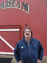
 Going back to the Superstition Saloon a little more than two years later, nothing much has changed. The dollar bills were still all over the walls and the beer was still cold. I had a Rattlesnake beer and talked with the bartender. She urged me to continue driving east on Route 88 and drive the Apache Trail. She told me that I would get some awesome pictures of the desert. I had a great opportunity when I got back home to talk with Lois Sanders. She is Tortilla Flats’ historian and has written a book and articles about the history of Tortilla Flat and the Saloon. We had a very nice conversation about how the saloon came to be and how this town seems to come back after both a major flood and fire.
 Ms. Sanders explained the dollar bills on the wall for me. It all started years ago when prospectors, ranchers and other who worked on the Salt River Dams would pin their card with a dollar bill to the wall behind the bar. That started the tradition which is very much alive today. There was a fire in 1987 that destroyed the saloon as well as all of the dollar bills which hung on the wall. It was rebuilt by 1988 and when people around the world had heard of the fire, many sent a bill to post on the walls. Leaving the bills on the walls makes people feel like they are a part of the nostalgia of the saloon and as you can see have successfully filled these walls with dollar bills. The saloon has no idea how much money is upon these walls but do know that there is currency from 67 countries. None of the bills are removed. If you visit and would like to have a dollar bill and business card pinned to the wall, just let the waiter or waitress know. They will put it up for you. Because of space, they need to use a ladder now because the bills have covered almost every square inch of the place.
 In 1904, Tortilla Flat was nothing more than a stage stop from the valley to Roosevelt Dam being built at the time and was a stop for freight haulers, which is when most historians believe it got its start. It is called “The friendliest little town in Arizona.” It has a population of 6, and that is its current population. That’s it folks only 6 people, making it Arizona’s smallest official “community” that not only has a U.S. Post Office but is also considered a voter’s precinct. There is so much history about this tiny little town and I urge you, if you are interested to pick up Lois Sanders’ book and read more about the extensive history on the web. From 1904 and beyond, Tortilla Flat was a stop for construction workers and freight haulers making there way up to the Roosevelt Dam construction site. There is a one lane dirt road that leads to Roosevelt Dam still today.
 There are a couple of theories of how Tortilla Flat got its’ name. One is that Mr. John Cline, a Tonto Basin pioneer in a conversation with Postmaster Russell Perkins, was traveling with some people from Phoenix for some supplies when a flash flood stranded them in that flat area of the desert. According to Mr. Cline, they ran out of food and were left with only flour. The men made tortillas with the flour for food to which Mr. Cline named the flat Tortilla Flat. Now although that sounds like a good story, another version according to Connie Phelps who co-owned Tortilla Flat from 1948-1950 had a conversation with Mr. Cline when Mr. Cline was 95 years old. In that conversation, he explained to her what had actually transpired and would lead him to the name Tortilla Flat. Mr. Cline and his cowboys led the cattle into Phoenix and sold them. They decided to celebrate and drank too much. When they got back to the flat, they realized that they had not purchased any supplies while celebrating their sale of cattle and had only flour to use. This is what led Mr. Cline to name the flat Tortilla Flat. It is a great little stop on the way to Apache Lake and Roosevelt Lake if you decide to take the Apache Trail. More on the Apache Trail in the next entry.


 Four Peaks Brewing Company, Tempe, Arizona
 Four peaks offered a cask conditioned ale which was drawn from a beer engine. Fantastic! I won't elaborate more. When you find yourself in Tempe, definitely check out Four Peaks Brewing Company.
 Four Peaks Brewery